|
The Department of Water Resources is currently under the Ministry of Environment, Climate Change, Water Resources, Fisheries,Forestry Parks & Wildlife.
The Ministry of Fisheries and Water Resources is the government policy institution responsible for fisheries and water resources. Its mission statement reads: ‘‘to monitor the weather and climate in order to harness their positive impacts and to provide lead-time information for protection against negative impacts; develop and maintain rational and judicious exploitation and use of the national surface and ground water resources and fish products, guaranteeing a healthy, decent and sustainable standard of living for all, now and posterity’’.
Legal Status and Mandate:
Enacted on the 22nd of February 1979, the National Water Resources Council Act, among other things established the Department of Water Resources (DWR) and mandated to ensure water resources assessment, monitoring and management.
The functions and responsibilities of DWR include:preparing an inventory of water resources of the nation,coordinate the planning of technical requirements of the water resources services,preparing plans for investigating the rational management, use, control and protection of water resources,collecting, archiving, analysing and disseminating meteorological and hydrological data and products for various human uses,serving as the official voice in issuing weather warnings for public safety as well as the national authority and official source of information and policy advice on the present and future state of the atmosphere and other aspects of national weather and climate, in support of development,exploring the existence, location and behaviour of underground water and to ascertain the quantity of such underground water and executing and enforcing laws and regulations affecting water. These activities have positive implications for natural resource conservation. The Act also encourages the sustainable use of water resources.
Organizational structure:
The Department of Water Resources comprises five technical units (Divisions) in addition to Administration and Public Relations, namely: Meteorology, Hydrology, Rural Water Supply, Water Quality Monitoring and Control, and Communications and Data Analysis.
The Department is the lead government institution for the implementation of the United Nations Framework Convention on Climate Change (UNFCCC) and also the focal point of the World Meteorological Organization (WMO) and the Regional Programme on AGRHYMET (Agriculture, Hydrology and Meteorology) under the Interstate Committee for the Control of Drought in the Sahel (CILSS).
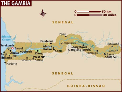
Gambia Meteorological Services
Central Forecast Office
Banjul International Airport
Department of Water Resources
Information under progress.
Please click to download the October-November-December 2015 Climate Publication Please click to download the January-February-March 2016 Climate Publication Please click to download the April-May-June 2016 Climate Publication
SATURDAY 10TH DECEMBER 2016 Tonight: Variably cloudy, dry and relatively cool conditions will prevail. Tomorrow: Partly cloudy and cool in the morning, becoming warm in the afternoon. Winds: The surface wind flow will be mainly Northeasterly in direction and light to moderate in speed (09 to 27km/hr) during the period. The sun is expected to rise over Upper River Region at 7:10AM and over Greater Banjul area at 7:20AM; and will set at 6:38PM and 6:28PM over Upper River Region and Greater Banjul area respectively. Temperatures: The lowest minimum value is expected to be 16°C over Upper River Region; whereas, the maximum value is expected to reach 37°C over Inland Region. EXPECTED EXTREME TEMPERATURES FOR SUNDAY 11TH DECEMBER 2016
OUTLOOK FOR MONDAY 12TH DECEMBER 2016 Dry and cool atmosphere will prevail in the morning ,becoming partly cloudy and warm in the afternoon. OUTLOOK FOR TUESDAY 13TH DECEMBER 2016 Partly cloudy, dry and cool in the morning, becoming warm and sunny during the period.
FROM 6:00PM THU 17TH NOV UNTIL 6:00PM FRI 18TH NOV 2016. Warnings: NONE SHIPPING FORECAST FROM 1200 UTC THU 17TH NOV UNTIL 1200 UTC FRI 18TH NOV 2016 Wind Warnings: Nil. The ITCZ is centered over the coast of Sierra-Leone, stretching southwestwards into the tropical Atlantic Ocean 10?N 20?W. Offshore Waters- 1 & 2 Wind: Northerly to northeasterly; 4 or 5. Sea state: Moderate Weather: Fair Visibility:Good Inshore Waters- 1 & 2 Wind:Northerly to northeasterly; 4 or 5. Sea State: Slight to moderate Weather: Fair Visibility: Good =
Early Warning Bulletin (May 1- 10,2016) Early Warning Bulletin (May 11-20,2016) Information under progress.
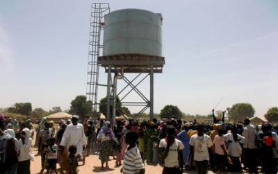
HYDROLOGY DIVISION The Hydrology Division under the department of Water Resources which was established by the 1979 Water Resources Council Act and mandated to ensure water resources assessment, monitoring and management. The division is task with the collection, analysis and archiving of the hydrology and hydrogeological data for human uses. In fulfilling these task, the division embarks on the following major activities; Discharge measurement, Water level measurement, Salinity flow measurement, Groundwater Assessment, Water Resources Planning for sustainable socio-economic development. Recent Developments The Gambia has recently witnessed tremendous improvement in its hydrogeological monitoring network after a decade or so long dysfunctional network. The support came from The Government of The Gambia, African Water Facility (AWF) under African Development Bank (AfDB) in a project called the National Water Sector Reform Project (NWSRP). The project was launched in June 2011 and it should phase out in September, 2015. The main objective of the project was to help the Government establish the Integrated Water Resource Management (IWRM) in line with the National Water Policy and the IWRM road map. The project support was in the form of rehabilitation and construction of the hydrogeological network infrastructure and provision of data acquisition devices/equipment etc. The Hydrological Network for data collection Surface water stations(water level, discharge and salinity) Stations installed with Ecolog 800 devices Station code Station name Parameters measured Banjul Water level, salinity, water temp. TDS, EC Tendaba Water level, salinity, water temp. TDS, EC Ballingho Water level, salinity, water temp. TDS, EC Pakaliba Water level, salinity, water temp. TDS, EC Kaur Water level, salinity, water temp. TDS, EC Kuntaur Water level, salinity, water temp. TDS, EC Bansang Water level, salinity, water temp. TDS, EC Basse Water level, salinity, water temp. TDS, EC Stations installed with Side Looking Doppler (SLD) device Fatoto North Discharge, Water level Fatoto South Discharge, Water level Sami Tenda Discharge, Water level Please click to download the Ground Water Monitoring Network: Ground Water Monitoring Network
Click to view the report on the installation of the ACPC support equipment Click to view the Updates of the Hydrological Situation on the saline front and the water level fluctuation. Update of the Saline front and Water level fluctuation
Water Quality Laboratory is responsible for monitoring the quality of both surface and ground water. Information will be available every 3 months. |
||||||||||||||||||||||||||||||||||||||||||||||||||||||||||||||||||||||||||||||||||||||